This weekend, 18-21 February 2022, are the four days of the Great Background Bird Count. This is a global community science project in which people go out and document bird life. The beauty of a project like this is that is available to anyone who has a window to the outside. Of course, anybody can look at birds any time. To participate in the official project, people need to add their observations to eBird, which is similar to iNaturalist only specific to birds.
Day 1
Date/time: Friday 2022-02-18, 09:00-10:00 Location: Younger Lagoon overlook Weather: Sunny, with very slight overcast; no breeze at first, but light breeze after about 09:30
Canada goose (Branta canadensis): 6
Mallard (Anas platyrhynchos): 4 female, 4 male
Bufflehead (Bucephala albeola): 4 female
American wigeon (Mareca americana): 4 female, 5 male
American coot (Fulica americana): 12
Northern harrier (Circus hudsonius): 1
Red-tailed hawk (Buteo jamaicensis): 1
Red-winged blackbird (Agelaius phoeniceus): hard to say, but at least 20 lekking away in the field across the lagoon
Osprey (Pandion haliaetus), carrying a fish!: 1
European starling (Sturnus vulgaris): murmuration of ~100
Bewick’s wren (Thryomanes bewickii): 1
Song sparrow (Melospiza melodia): 2
Yellow-rumped warbler (Setophaga coronata): 2 male
In addition to this tally of species, which is fine in and of itself but not all that interesting, I did get to see some interactions. The northern harrier is a perennial resident, and I often see it either perched on a fence post across the lagoon or soaring low over the fields. Today the red-tailed hawk was perched on a fence post, and I didn’t see the harrier until it flew in several minutes later. The harrier crossed in front of the hawk, flying low, and flushed out a murmuration of starlings. It chased the starlings around for a little while, obviously not hunting them. And as much as I wish starlings hadn’t been introduced to North America, the flow of a murmuration is fascinating to watch. Even a small one of about 100 birds is rather impressive. Anyway, the hawk on the fence post watched all this activity for a few minutes and seemed to be rather peeved by all the kerfuffle. It ruffled its feathers and flew off. The harrier flew away later, and the starlings kept up their murmuration until I left.
At ~05:00h UTC on 15 January 2022, the Hunga Tonga Hunga Ha’apai undersea volcano erupted. The eruption was probably followed by a massive undersea landslide, which set tsunami waves out across the Pacific Ocean. This time translates to ~21:00h PST on Friday 14 January, and for the rest of this entry all times and dates will be reported in California time. The eruption and landslide happened in the early morning in Tonga, which was the previous evening here in California.
I woke up on Saturday 15 January (yesterday, as I write this on the 16th) to reports of tsunami warnings for the entire Pacific coast of North America. The first waves were expected to hit the Monterey Bay area around 07:30h. Knowing that we are in spring tides now and that the low low tide (LLT) would be at 15:35h, I back-calculated the preceding high tide (the high high tide, or HHT, for the day) to be around 08:30h. Hmm. High tide plus tsunami surge could equal interesting things to see! And yes, as we were warned not to go down to the ocean, I planned to remain above it all and observe from the bluffs.
What the instruments measured
The volcano erupted first, and caused the landslide. When the massive displacement of water occurred in the ocean, it sent pressure waves through both the ocean and the atmosphere. But before that, the volcanic explosion itself created a pressure wave in the atmosphere. And it happens that the barometer in our weather station caught the pressure anomaly! At 04:04h on 15 January, about seven hours after the eruption, the weather station measured a spike in atmospheric pressure (circled in red in the bottom panel). Our weather station records pressure only every five minutes, so the actual spike may be a bit higher than what was recorded.
Spike in atmospheric pressure, measured by our weather station in Santa Cruz, CA
The National Oceanographic and Atmospheric Administration (NOAA) has tsunami stations established on the entire coast of the U.S., as well as earthquake monitoring stations elsewhere along the Pacific ring of fire. The tsunami station at Monterey measured sea level anomalies due to the tsunami waves striking the coast, starting at about 07:00h, as seen below.
This kind of chart is a little different from what you’re probably used to, so let me explain what it shows. You have time and date along the X-axis. The blue line, which is hard to see because it is mostly obscured by the red line, is the predicted sea level; note that it follows the usual trajectory for the tides we have in this area, with two high tides and two low tides every day. The jagged red line is the interesting part. It shows the anomalies, or how the actual sea level deviates from the predicted sea level. There are both positive and negative anomalies. These anomalies are the tsunami surges that hit the monitoring buoy. Positive anomalies are the pressure waves striking the buoy (i.e., the crests of the wave), and negative anomalies are the pauses between surges, or the troughs of the wave. The first large anomaly was about 0.7 meters above the predicted sea level.
Imagine tossing a pebble into a calm pond. When the rock hits the water it sets up a series of pressure waves that emanate in all directions from the point of impact. If you watch those waves, or ripples, you notice that over time they diminish in size until eventually you don’t see them anymore.
A tsunami is a similar phenomenon, only ginormously magnified. The underwater landslide displaces a huge amount of water, which then surges away in all directions. These tsunamis travel across thousands of kilometers of open ocean, where they may not make much difference in sea level. But as they approach land they behave like other waves do: they slow down and get taller. When they hit the continental shelf, they surge up coastal waterways and flood any low-lying land they encounter.
And there isn’t only one surge. As you can see in the NOAA chart, surges and relaxations occurred throughout the entire day. The purple line indicates the same anomalies as the red line, only they are shown on a single horizontal line instead of on the wave of the blue line. This makes it easier to see how the magnitude of the deviations decreases over time.
What I saw
Double-checking the NOAA tide chart for Santa Cruz, I saw that the HHT would be +1.7 meters at 07:59h. I managed to get myself down to the marine lab, do my chores, and scurry out to Younger Lagoon at about 08:45h. Don’t worry, I didn’t have time to go down onto the beach, but watched events from the bluff, where I had a better view anyway. Remember, we had a high tide coinciding with the oncoming tsunami surge, so the potential was there for something interesting to happen. Now, a +1.7 meter (= 5.5 feet) isn’t an extremely high tide. But combined with a tsunami surge, maybe that would be enough to flow over the sand berm into the lagoon.
And that’s what happened. From my position on the bluff I recorded this video:
Things were pretty exciting at the Santa Cruz Small Craft Harbor, too. All day, people were recording the tsunami surges as they rushed up the harbor from Monterey Bay. Unlike the tsunami in 2011, which tore up both docks and boats, causing extensive damage, yesterday’s tsunami was quite mild. I had already made plans for the day and didn’t get down to the harbor to check out the action until late in the afternoon. My friend, Murray, built a little boat, Scherzo, who lives in the upper harbor. Scherzo didn’t exist in 2011 so we don’t know how she would have weathered things. She was floating happily when we went to see her yesterday, although she did seem to be sitting rather low in the water. She probably took on water over her transom during the biggest tsunami surges.
Scherzo is the sleek little craft on the near side of this dock. She is blue with a white cover.
The harbor patrol had blocked access to the docks so they could inspect them for structural damage. I assume, but don’t know for sure, that slip renters were able to check on their boats today.
We were at the harbor at 16:30h yesterday. Sea level was still noticeably rising and falling, and even a minute of watching was rewarded with fairly drastic changes. Since we were not allowed onto the docks I was unable to record good footage of how quickly water was moving in the main channel. However, in the side channel where Scherzo is tied up we could watch the water drain. In this video, keep an eye on that rock that looks like a shark fin, near the middle of the frame.
What other people saw
In one of those inevitable consequences of any public safety announcement, the effect of a tsunami warning is to attract people to the beach. I know that many surfers headed out to surf the tsunami, and a lot of people recorded the tsunami from bridges and other places. Here are just a few of the YouTube videos showing the tsunami in the Santa Cruz area.
Video #1: Drone footage of the tsunami pushing into the mouth of the harbor and up the main channel. You can clearly see the green water from Monterey Bay pushing its way through the muddier water of the harbor itself. And the poor dredge sure did take a beating!
Video #2: This video was shot from the Murray Street bridge, looking south at the lower harbor
So yeah, things were pretty exciting here. But the important thing to remember is that what was a source of entertainment and mild concern here in California, caused tremendous damage in Tonga and neighboring islands. Volcanic ash is settling over the island to the depth of several centimeters, fouling fresh water supplies. The ash is also clouding the air and darkening the sky. Communications have been disrupted, and it is unknown how many casualties resulted from the eruption and ensuing tsunami. Australia and New Zealand have begun deploying aircraft to assess the damage, but it will be a while before we know how bad things really are. Drinking water does seem to be the most pressing need for Tongans and inhabitants of other affected islands.
I imagine that in the coming days there will be opportunities for us to help those who need it. If you can contribute, please do so.
On this winter solstice, as we anticipate the return of light, I thought I’d write about a different kind of light.
Merriam-Webster defines fluorescence as “luminescence that is caused by the absorption of radiation at one wavelength followed by nearly immediate reradiation usually at a different wavelength and that ceases almost at once when the incident radiation stops”. It is a type of luminescence that occurs in both biological and non-biological objects. For example, mushrooms and scorpions are notably fluorescent, as are several minerals. Technically, to qualify as “fluorescent” an object can absorb any wavelength of radiation and re-radiate any other, although the re-radiated wavelength is usually longer than the absorbed wavelength.
We humans, with our three (and occasionally four) color photoreceptor types, can see only the tiny fraction of the electromagnetic spectrum that we call visible light. The visible light range (approximately 400-700nm) is bounded by UV on the short end and infrared on the long end. Other organisms have very different light perception capabilities. We know, for example, that insects can see in UV and pit vipers can see in infrared. And as for mantis shrimps, which have as many as 12 types of photoreceptors, we don’t yet understand how they see the world, but you can bet it’s nothing like the way we do. For practical purposes, fluorescence is most easily seen when an object absorbs UV light and re-radiates light of a longer wavelength that falls into the visible light range.
When you shine a UV light on one of these fluorescent objects, you see an apparent color change from whatever it looked like under visible light. This color change is most striking in the dark, because the fluorescent object will appear to glow. The same thing happens in daylight, but is obviously more difficult to see.
Here, let me show you. A few weeks ago I went to Natural Bridges to photograph the anemones, first under normal daylight conditions and then under UV light. I have a pretty wimpy UV flashlight, it turns out, but you can still see the fluorescence.
Here’s what’s going on. Pigment molecules in the anemones’ tissues are absorbing the UV radiation and re-radiating light in the visible range. It’s easier to see the fluorescence in Anemone #2 because it was much darker when I took that set of photos. Fluorescence still occurs during the day, but we can’t see it as well in the daylight. This is why our local bowling alley does their Atomic Bowling at night! They can dim the overhead lights, crank up the black lights, and let the tunes roll.
Incidentally, if you’ve ever wondered why so-called black lights are purple, there’s a reason for it. A true black light emits only UV light. UV light is invisible to us, hence the term “black”, as in pure darkness. UV lights that ordinary folks like us can buy are tinged purple so that we can see it. The purple isn’t UV, of course, but seeing the purple light keeps people from looking into the beam and frying their retinas from the actual UV radiation.
Sea anemones, of course, do not celebrate the solstice, but they do perceive it. They, and just about every other living thing, can sense the cyclical changes in day length as the year progresses. After tonight the days will start getting longer as we move through winter and towards spring. Personally, I cannot wait until we get the early morning low tides in the spring.
Yesterday I had some time to kill before getting a COVID test, and, as usual, wandered down to the ocean. This time I was at Seacliff State Beach. It was pretty crowded, so I walked onto the pier to see if the fishermen were having any luck. They weren’t, really. One man kept catching jack silversides (Atherinopsis californiensis) that were too small to keep. There was a lot of banter about sharks and bait and crabs, but what I witnessed yesterday confirms my hypothesis that a lot of what people call “fishing” is merely an excuse to get outside for a few hours. And there is absolutely nothing wrong with that.
As for me, I have nowhere near enough patience to make a decent fisherman. I did, however keep myself amused by eavesdropping on their conversations and writing snippets in my nature journal. I did also find myself mesmerized by the anchovies. Watch for yourself.
Like sardines, anchovies are planktivorous filter feeders. If you watch the video again and can focus on an individual fish for a while, you’ll see that as it swims forward, the front end becomes white and bulbous for a few seconds. That’s sunlight reflecting off the fish’s jaws. Anchovies have metallic silver coloring, which is a defense against predators. For fish that live in surface waters that are brightly lit, all of those glinting flashes of light make it difficult for a predator to zero in on a single fish to pursue. There is safety in numbers, and for anchovies the silvery coloring combined with schooling behavior means that if a predator manages to catch some of the fish in the baitball, most will avoid being eaten. This works against predators such as larger fish, squid, and birds, which generally capture one or a few fish at a time. But if the predator happens to be a humpback whale, which is capable of engulfing the entire school, then the anchovies are SOL. Think about it, though. For any anchovy, the probability of encountering a larger fish, squid, or bird is much higher than encountering a humpback or blue whale. Thus the selective advantage of schooling!
Okay, now back to the feeding. Anchovies have really long jaws for their size and can, like snakes, open their mouths very wide. This allows them to filter as much water as possible as they swim. Food, mostly plankton, is caught on the gill rakers, which are bony or cartilaginous structures projecting forward (i.e., towards the mouth) from the gill arches. Some fishes’ gill rakers are nothing more than short nubs. Filter feeding fishes such as anchovies have long thin gill rakers. Water enters the mouth as the fish swims forward, and plankton is caught on the array of gill rakers. The water then passes over the gill filaments, where respiratory exchange occurs, and then out from underneath the operculum. Anchovies cannot suck water into their mouths, and thus can feed only while swimming forward, or ramming water into the mouth. This is a type of feeding called ram feeding.
These anchovies were very close to shore. They were feeding, so obviously there was plankton in the water. I haven’t done a plankton tow in a while, as I generally assume that fall/winter plankton isn’t as interesting as spring/summer plankton. However, given the presence of feeding anchovies inshore, it might be time to test that assumption.
I go to Natural Bridges quite often, to play in and study the rocky intertidal. But at this time of year, before the low tides really get useful, there is another reason to visit Natural Bridges—to see the monarch butterflies (Danaus plexippus). Natural Bridges State Park is a butterfly sanctuary, providing a safe overwintering spot for migrating monarchs.
Yesterday morning, while it was still cool enough for the butterflies to be hanging in clusters, I went out and photographed them. Last year’s count was only 550 for the winter, but I’d heard that there were more butterflies this year and it was definitely worthwhile going out and looking for them.
The butterflies rest with their wings up, so when they are hanging like this you see the duller underside of the wings. A few of them were starting to warm up their flight muscles and showing off the more brilliant orange of the dorsal wing surface.
I am really not good at counting things like this, but my guess is that there were hundreds of butterflies, all told. Based on the 2020 season, when I didn’t see any monarchs at all at my house and only a few scattered individuals at Natural Bridges, this year’s population seems to be doing much better. 2020 was an awful year in California in general, and in the Santa Cruz region in particular. The CZU August Lightning Complex fire put air quality into the unhealthy-for-everybody range for several weeks. Much of the rest of the western U.S. also burned, with much habitat loss for nature. Maybe that’s part of why there were so few monarchs last winter in Santa Cruz. Of course, the monarchs’ populations have been declining for years, so last year’s population crash may be only a dip in the grand scheme of things.
Whatever the cause, it really was good to see even this many butterflies at Natural Bridges.
Oh, and before starting my butterfly hunt in earnest, I spent about an hour watching and listening for birds. I wanted to get the birdwatching in before human activity drowned out the birdsong. Unfortunately, most of what there was to hear was the cawing of crows.
Page from my nature journal
Next time I’m at Natural Bridges, I’ll try to remember to check in with the visitor center to see what the official count for monarchs is. Fingers crossed the number is a lot higher than 550!
Over the weekend the atmospheric river slammed into Northern California and settled over us for a few days. Our weather station at home, roughly at sea level, measured 4.5 inches of rain. On Sunday afternoon it was extremely windy, and I think the rain wasn’t falling vertically enough to be captured by the rain gauge, and my guess is that another half-inch or so fell but wasn’t measured. A total of about 5 inches of rain feels right.
This storm was a very big deal for us, for a couple of reasons. The most obvious is that California is in the midst of another severe drought. There wasn’t much rain or snowfall at all in the 2020-2021 rain season, reservoirs are drier than I remember seeing them, and the governor has asked residents to reduce water consumption statewide by 15%. We are woefully short of that conservation mark. So yeah, the amount of water available to all consumers is (or should be) of concern to all of us.
A second reason why we all paid so much attention to this storm was the fact that much of the rain was forecast to fall on areas that had burnt recently, including the 2020 CZU Lightning Complex fire burn scar. Both the 2020 and 2021 fire seasons were horrendous, leaving many acres of previously forested land bare and prone to mudslides, or “debris flows” in modern parlance. Residents in the Santa Cruz Mountains were warned to prepare for evacuation, just in case. And everyone was prepared to deal with power outages, which, oddly enough, didn’t happen.
On Friday the 22nd, before the major storm blew in, I went to Younger Lagoon to record some video clips for my Marine Biology class. One smaller storm had already blown through and it was very windy. I encountered two birders who were looking for pelagic birds that had been swept into the lagoon or were seeking shelter from the elements.
In fact, here’s the video I put together for the students:
So that was Friday. On Saturday we went hiking at Moore Creek Preserve with our god-daughter and family. We all wanted some quality outdoors time before the major storm event on Sunday/Monday.
Yesterday (Monday) I went back to Younger Lagoon to see how much it had changed with all the rainfall. I could tell from the smell that the sand berm hadn’t been breached yet. We can always tell when the lagoon breaks through, because all of the hydrogen sulfide buried in the sediment gets into the air. It’s a smell that, once known, is difficult to forget. Anyway, I took a photo of the top of the lagoon from the same spot as on Friday. And see how much difference one big rain event can make:
To make the comparison easier, let’s look at those photos side-by-side:
2021-10-222021-10-25Younger Lagoon before (left) and after (right) the bomb cyclone storm of 2021-10-24
We had a high surf advisory yesterday, so I wandered down into Younger Lagoon to check out the ocean conditions. I could hear that the surf was really big. It was still windy, too.
Just to make sure my intuition was correct, I stopped to check out the sand berm. And yes, it was still there.
The waves were big and the sets were coming in fast. I shot this video at about low tide yesterday morning. We’re in neap tides right now so the low wasn’t very low.
Storms and tidal surge, when combined, can wreak havoc on nearshore coastal habitats. One of the obvious victims of the recent violence is the kelp bed. The kelps have been on their seasonal decline for weeks now, and the storm-strengthened swell tore up a lot of kelp and deposited it on the beach. Thousands of detached pneumatocysts (floats) of Macrocystis pyrifera had been blown into windrows. The lighter colored pneumatocysts are the ones that were washed up earlier, probably in the second-most-recent high tide; the darker ones were deposited during the most recent high tide, about six hours earlier.
I expected to see dead animals on the beach, too, and was surprised that there weren’t any carcasses in sight. Then I looked across the beach with binoculars and saw a couple of turkey vultures (Cathartes aura) on the sand, and a third on the fence above. Vultures eat carrion, so there must be a corpse over there after all. Sure enough, there was a dead bird. As I approached I saw a black body with a smaller reddish part, and my first thought was, “Are turkey vultures cannibals? Will they eat their own dead?” because turkey vultures have unfeathered red heads. But when I got closer I could see that this corpse had webbed feet. It was, in fact, a cormorant.
The scavenging turkey vultures flew away as I approached. I didn’t want to interrupt their brunch any longer than necessary, so stuck around just long enough to snap a few photos. By the time I had crossed back to the near side of the beach, they had returned to their feeding.
All told, this storm was a good start to the rain season. It put an end to the fire season, which is a huge relief to all of us living in California. We have a long way to go to return to normal rain levels, whatever they are in this era of anthropogenic climate change, and it irks me to hear people saying that we’ve had a lot of rain now, so the drought must be over. Too bad it doesn’t work that way, or we would all be rejoicing big time.
Climate change models predict, among other things, oscillation between extreme rain events and extreme drought in California. Just in the past handful of years we’ve had drought plus the Blob (2015), a wet winter in 2016-2017, and a return to dry conditions from 2018-2020. And we all remember the extreme fire seasons of 2020 and 2021. So what is “normal” these days? I think it’s impossible to know. We are experiencing climate change as it happens, and we don’t know how or when things will begin to stabilize. I suspect it won’t be within the lifetime of anyone reading this blog.
Still, after having about zilch in the way of rain last year, it’s good to see that Mother Nature can still throw an atmospheric river at us. Fingers crossed for more rain as the season continues.
Over the weekend we had dinner with some family members down in Monterey, and my niece gave me a leaf. She had collected it somewhere and carried it around for a while, and I never did get a clear answer about where it came from. To me it looks like a magnolia leaf. When I said it looked like a fun leaf to paint, she told me I could take it home.
December’s leaf
The next day I sat at my desk and studied the leaf for a while. And, as most things do, the leaf became more complicated the longer I looked at it. The shape wouldn’t be difficult to get on paper, but I wanted to work with the colors. I always think that getting the right color is easier with colored pencils than watercolors, so I started with what I assumed would be the greater challenge.
As anticipated, I had real difficulties with the highlights. I still haven’t figured out how to paint shine. And in retrospect it might have been better to paint wet-on-wet instead of letting the paint dry before adding more color.
And that shape, which I thought would be a slam-dunk? I was so wrong about that! The paper in my sketchbook isn’t heavy watercolor paper at all, and with all the erasing I had to do to get that foreground curve right I was afraid I’d remove too much of the texture. I like the overall effect, and I did kind of get the perspective right, which is always hard for me. I stopped before experimenting more with the bright highlights because I didn’t want to overwork this sketch. I still don’t know what to do about those.
Now, onto the pencil version.
As I noted in the sketchbook, what I thought would be easier ended up being not. I do like the color rendition here, and I think the toned paper works well. And as an aside, the Prismacolor Black Grape pencil does make pretty shadows. In this sketch I positioned the highlights with too much symmetry, and as a result this leaf looks like a feather. It might look better if I made the veins more visible. I can still do that.
Looking at both of these sketches, I think I like the watercolor version better. What do you think?
Over the past couple of weeks I’ve rented two super telephoto lenses, to see what all the hype was about. I mean, do I really need 500 or 600mm of reach? I had read up on the specs of such lenses, and one major drawback is the weight—1900 grams or more. Would I be willing to lug a beast like this around, and would I be able to use it effectively? You never know until you try, so I rented them. And, of course, it was foggy both weeks so I didn’t have much opportunity to take decent photos. But since the entire point of renting the lenses was to see if I could use them at all, that was fine.
As part of the test-drive for the second lens, I went up to Waddell Beach to see if there would be any birds to photograph. It is migration season, and our winter residents will be arriving soon. Some of them, such as the red-necked phalarope, have shown up at Younger Lagoon over the past four weeks or so. It was really foggy at Waddell, remember, and I didn’t have much hope of seeing anything remarkable. There were some gulls and whimbrels off in the distance. But it turned out that the stars of the show were blackbirds!
They were hard to miss, because there were 50-60 of them and they were hopping up and down like jumping beans.
This is a mixed flock of Brewer’s blackbirds (Euphagus cyanocephalus) and red-winged blackbirds (Agelaius phoenicius). The glossy greenish-black birds are the male Brewer’s blackbirds, and most of the brownish birds are female Brewer’s blackbirds. Since both sexes were doing the hopping, I didn’t think this behavior had to do with courtship or mating.
So yes, while most of the birds seemed to be Brewer’s blackbirds, I did hear the liquid gurgling of the red-winged blackbird’s song coming from somewhere in the flock. When I got home and looked at the photos on the big monitor, I did see some red-winged blackbirds. Here’s a male, surrounded by other males red-wingeds and both female and male Brewer’s blackbirds.
In this photo above the black birds are male Brewer’s blackbirds. The brown birds without faint wing bars are female Brewer’s blackbirds, and the brown birds with the wing bars are male red-wingeds. There were no female red-winged blackbirds in any of my photos. According to an article from Cornell’s Bird Academy, the males spend the weeks leading up to springtime competing for territories, and when the females return from their winter migration they will choose mates based partly on the quality of the territory. Mid-September is too early for this kind of competition, though. We are just about up to the autumn equinox, but not near winter quite yet.
Back to the hopping. There’s a clue in this photo about what I think was going on:
See that little fly? There were many such flies, most of which were lower on the beach gathering around the kelps and other wet detritus that had washed up. There were fewer flies up where the driftwood accumulates, though. Once again, it wasn’t until I saw the pictures on my big monitor that I could figure out what those blackbirds were doing. They were hopping up to eat flies!
Here’s a series of shots showing one of the male red-wingeds in mid-hop.
I don’t have any hard evidence that the blackbirds (both Brewer’s and red-wingeds) are catching flies. And while I was at the beach watching them hopping up and down I had no idea what they were doing. However, now that I’ve seen the flies in the photos, it makes sense that the birds would be hopping up to catch and eat them, especially since both sexes of the Brewer’s blackbirds were doing the same thing.
One year ago today a lightning storm settled over the Santa Cruz Mountains and dry lightning ignited a bunch of wildfires. Given the drier-than-normal conditions at the time the fires took off like crazy and eventually merged into one megablaze that CalFire dubbed the CZU Lightning Complex fire. The CZU Lightning Complex fire burned over 80,000 acres in Santa Cruz and San Mateo Counties before being contained by CalFire on 22 September. It raged through Big Basin Redwood State Park and destroyed the buildings at the park headquarters up in the mountains. Several mountain communities were threatened, with over 1400 structures destroyed. I personally know two families whose homes were lost, and many others who evacuated. We were also ready to evacuate, with bags packed and a place to flee to.
To commemorate the first anniversary of the CZU Lightning Complex fire the Santa Cruz Museum of Natural History and the Santa Cruz Public Library put together a series of events called “CZU and You” to teach the public about this particular natural disaster. This past weekend we attended a walk through Rancho del Oso, led by Richard Fletcher, who is one of the California State Parks interpretive rangers. Rancho del Oso sits in a little valley that I think of as the “bottom” of Big Basin Redwood State Park. It ends at Highway 1 directly opposite Waddell Beach. In previous years I have taken my Ecology class to Rancho del Oso for the first field trip of the semester. Rancho del Oso was cleared to reopen for visitors on weekends only just a few weeks ago.
The Nature and History Center at Rancho del Oso is housed in the building that was the residence of Hulda Hoover McLean, who was the niece of President Herbert Hoover. Hulda and her husband, Charles, raised a family in the Rancho; Hulda taught her children about the natural history of the area. She sold her 40 acres of land and her home to the Sempervirens Fund in 1985, with the intent to create a place where people could visit and learn about this part of the natural world. There was one ranger on site on August 16, 2020 when dry lightning ignited the fire on the hillside directly across Waddell Creek from the nature center. He managed to flag down a single fire truck and crew. Working through the night this handful of people built a backfire to burn up the hill towards the flames that had sped around the house and were approaching from the other side, and sweeping off the burning embers that landed on the roof
The first things that Ranger Fletcher showed us were some cones from Monterey pine (Pinus radiata) trees. He described this species is being moderately serotinous, meaning that seeds don’t fall out of the cones until they are exposed to the heat of a fire. Heat dries and opens up the cones, allowing the seeds to fall and be dispersed.
Unopened cones of Pinus radiataScorched and opened cones of Pinus radiata
In the area this backfire burned, literally across the driveway from the nature center, we could see some of the fire followers. These are the first plants to show up after a fire. Some of them may have arrived by seed, but many are regrowth from underground roots or bulbs.
The naked lady lilies (Amaryllis belladonna) are non-native ornamental bulbs that have been planted in gardens all over the region. They are called naked ladies because their leaves die back completely before the stalk blooms in late summer; you can see all the brown leaves at the bases of the flower spikes. In this first bloom season after the fire they seem more vibrantly pink than usual. The other foliage in the foreground is a blackberry (Rubus sp.) that could be either native or not. In the background you can see some bracken fern (Pteridium sp.).
After a disturbance such as a fire the process of ecological succession is reset. Given the European colonizers’ habit of suppressing all fire, it had been at least 100 years since the Waddell Valley burnt. In the many decades since the previous fire the homesteaders and ranchers had planted all sorts of non-native ornamental plants in their gardens. The naked ladies and invasive blackberries are examples of plants that are well suited for our Mediterranean climate, and they certainly made a showy return after the CZU Lightning Complex fire.
Fortunately it’s not just the non-natives that are coming back. The ranger was excited to point out that one yellow bush lupine (Lupinus arboreus) had popped up on this same slope. Lupines are good plants to have on burnt slopes because they help stabilize the soil. They are also nitrogen fixers, which makes the soil more hospitable to other, hopefully native, plants.
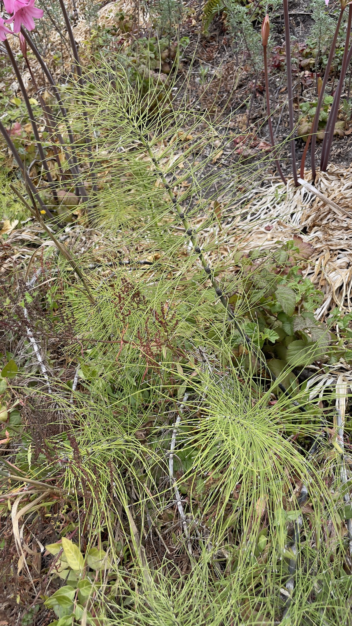
One plant that I hadn’t expected to see in this location is Equisetum, the horsetail. There is a lot of Equisetum along the Marsh Trail, and I associated this plant with wetlands. So why was it growing on this particular slope, which is measurably drier than the Marsh Trail? It was growing really well, too!
We hiked the Marsh Trail—how could there be so many mosquitos when we’re in such a bad drought??—and crossed Waddell Creek to where the Skyline to the Sea trail ends (or begins, if you were to start at the beach and hike uphill). This is where Ranger Fletcher told us more about the fire itself and its ongoing effects.
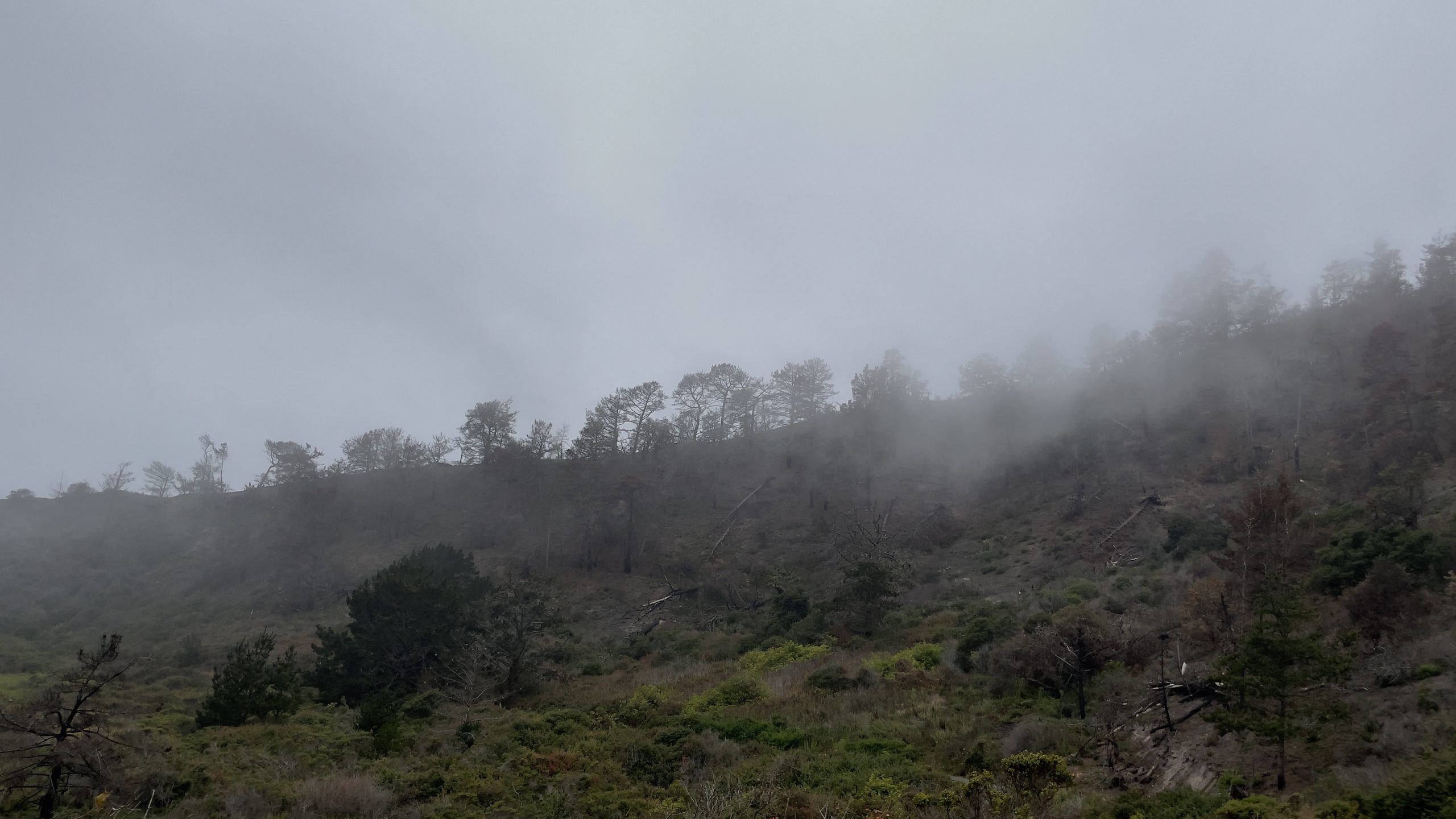
We were hiking at Rancho del Oso on a foggy morning. It was so very different last year, when the marine layer abandoned us early in the summer and left us to dry out just in time for the dry lightning in mid-August. But this is the area where the first lightning strikes hit ground:
Once the fire was extinguished this hill was covered with black, burnt vegetation. Anything green is vegetation that has grown since then.
CalFire declared the CZU Lightning Complex fire contained on 22 September 2020 and controlled on 23 December. What nobody knew at the time was that the fire remained burning underground. Considering their great height, redwood trees don’t have deep roots. But they have lateral networks of roots that entwine with those of neighboring trees (which are likely to be clonemates) and form a more or less solid mesh that holds all of the trees up. The fire travelled along this root network and continues to burn. One of our group asked “What is there to burn, if the roots have already burnt?” and Ranger Fletcher explained that now there are tons of charcoal buried in the ground, and we all know how well charcoal burns, right? Not being able to detect where roots are burning underground means it’s difficult to evaluate trails and know when they are safe. Just last week a ranger was working up at Big Basin and stepped into what turned out to be a cavern containing burning embers. CalFire estimates that the fire will continue to burn underground for another four years. Trees that were weakened or killed by the fire will also be falling. It will be several years before the Skyline to the Sea trail opens again. But in the lifespan of a redwood forest, five or even ten years would be a blink of the eye. And I’d just as soon not step into a burning hole while hiking, thank you very much.
On this side of Waddell Creek you can see the meadow that acts as a buffer zone between the mountains and the ocean. When wildfires burn through hilly areas, we worry about winter rains causing mudslides. This past winter we got hardly any rain at all, so at least the mudslides didn’t materialize. But even when there aren’t mudslides, a lot of nutrients wash downhill towards the ocean. The meadow is a biological sponge that soaks up these nutrients and keeps them from creating problems in the marine habitat. This is one of the reasons that wetlands are such important players in the health of coastal ecosystems. I took this photo from the Highway 1 bridge that crosses Waddell Creek. Just on the other side of the highway the creek spills onto Waddell Beach.
From a fire behavior perspective the CZU Lightning Complex fire was unusual. Fires usually burn up hills, but this one burned downhill towards the ocean. Waddell Beach is almost always foggy, and the marine layer can be felt away from the beach, as it was on our most recent visit to Rancho del Oso. This marine influence should have acted to keep the fire from racing downhill as fast as it did. Alas, the marine layer was not doing its job last summer. If it had been, we wouldn’t have seen so many lightning strikes in the first place. The paucity of rain from the previous winter didn’t help things, either. Climate change is coming back to bite us in the ass. Around the world we are seeing extreme weather events, from severe drought to equally devastating floods to heat records tumbling by the wayside. We are living in the era of anthropogenic climate change, and we will not be alive when an equilibrium returns to Earth’s climate. In the timeframe of a human lifespan, however, it is nice to see and document how this small part of the landscape is recovering from last year’s fires. Now that Rancho del Oso is open again I’ll try to get up there every so often to record changes in my nature journal.
For some reason, many of the sunburst anemones (Anthopleura sola) in a certain area at Davenport Landing were geared up for a fight. I don’t know what was going on before I got there yesterday morning, but something got these flowers all riled up. We think of them as being placid animals, but that’s only because they operate at different time scales than we are used to. A paradox about cnidarians is that they don’t do anything quickly except fire off their stinging cells; that, however, they do with the fastest known cellular mechanism in the animal kingdom. Go figure.
What looks like an anemone wearing a tutu is actually an anemone ready to fight. The normal filiform feeding tentacles are easily recognized. But those club-shaped white tentacles below the ring of feeding tentacles are called acrorhagi. They are all about fighting. The tips are loaded with potent cnidocytes that usually aren’t used to catch food. They are used to fight off other anemones, and possibly predators.
Here’s another shot of the same animal, which shows how the feeding tentacles and acrorhagi are arranged in concentric rings:
So who would this anemone be fighting? This individual was the only one of its kind in the pool where it lives. I don’t know why its acrorhagi are inflated. I suppose they could be used to fend off a would-be predator, but I didn’t see any other animal in the pool that seemed a likely candidate.
Now, clearly there is (or had been) something going on between these individuals. They both have their acrorhagi inflated. I’ve been looking at this photo for a while and can’t decide which is the aggressor. At first I assumed that the anemone on the right had initiated an attack on the other. But now I wonder if that is a defensive posture rather than an offensive one. That animal does seem to be more bent out of shape than the one on the left.
I’ve seen anemone fights before, and I’ve also seen anemones living side by side, tentacles touching, in apparently perfect amity. It’s very clear that they can coexist peacefully. Why, then, do they sometimes choose to fight? It’s important to point out that Anthopleura sola is an aclonal species. Unlike its congener A. elegantissima, whose primary mode of growth is cloning, each A. sola represents a unique genotype. With these anemones, whether or not two individuals fight is not determined by relatedness.
In a different pool these two anemones are sharing the carcass of a rock crab.
Maybe that third anemone at the top had also taken part in the feast, but at this point it seemed to be minding its own business. Given the demonstrated aggression of some A. sola, it would be interesting to know whether or not this trio ever fight amongst themselves. When we ‘ooh’ and ‘aah’ over them in the tidepools they look like passive flowers, and we forget that they are active predators. But we humans have access to the anemones’ home for only a few hours every month, and I have no doubt that they get up to all sorts of shenanigans when we’re not looking.