
One year ago today a lightning storm settled over the Santa Cruz Mountains and dry lightning ignited a bunch of wildfires. Given the drier-than-normal conditions at the time the fires took off like crazy and eventually merged into one megablaze that CalFire dubbed the CZU Lightning Complex fire. The CZU Lightning Complex fire burned over 80,000 acres in Santa Cruz and San Mateo Counties before being contained by CalFire on 22 September. It raged through Big Basin Redwood State Park and destroyed the buildings at the park headquarters up in the mountains. Several mountain communities were threatened, with over 1400 structures destroyed. I personally know two families whose homes were lost, and many others who evacuated. We were also ready to evacuate, with bags packed and a place to flee to.
To commemorate the first anniversary of the CZU Lightning Complex fire the Santa Cruz Museum of Natural History and the Santa Cruz Public Library put together a series of events called “CZU and You” to teach the public about this particular natural disaster. This past weekend we attended a walk through Rancho del Oso, led by Richard Fletcher, who is one of the California State Parks interpretive rangers. Rancho del Oso sits in a little valley that I think of as the “bottom” of Big Basin Redwood State Park. It ends at Highway 1 directly opposite Waddell Beach. In previous years I have taken my Ecology class to Rancho del Oso for the first field trip of the semester. Rancho del Oso was cleared to reopen for visitors on weekends only just a few weeks ago.

2021-08-14
© Allison J. Gong
The Nature and History Center at Rancho del Oso is housed in the building that was the residence of Hulda Hoover McLean, who was the niece of President Herbert Hoover. Hulda and her husband, Charles, raised a family in the Rancho; Hulda taught her children about the natural history of the area. She sold her 40 acres of land and her home to the Sempervirens Fund in 1985, with the intent to create a place where people could visit and learn about this part of the natural world. There was one ranger on site on August 16, 2020 when dry lightning ignited the fire on the hillside directly across Waddell Creek from the nature center. He managed to flag down a single fire truck and crew. Working through the night this handful of people built a backfire to burn up the hill towards the flames that had sped around the house and were approaching from the other side, and sweeping off the burning embers that landed on the roof
The first things that Ranger Fletcher showed us were some cones from Monterey pine (Pinus radiata) trees. He described this species is being moderately serotinous, meaning that seeds don’t fall out of the cones until they are exposed to the heat of a fire. Heat dries and opens up the cones, allowing the seeds to fall and be dispersed.


In the area this backfire burned, literally across the driveway from the nature center, we could see some of the fire followers. These are the first plants to show up after a fire. Some of them may have arrived by seed, but many are regrowth from underground roots or bulbs.
The naked lady lilies (Amaryllis belladonna) are non-native ornamental bulbs that have been planted in gardens all over the region. They are called naked ladies because their leaves die back completely before the stalk blooms in late summer; you can see all the brown leaves at the bases of the flower spikes. In this first bloom season after the fire they seem more vibrantly pink than usual. The other foliage in the foreground is a blackberry (Rubus sp.) that could be either native or not. In the background you can see some bracken fern (Pteridium sp.).

2021-08-14
© Allison J. Gong
After a disturbance such as a fire the process of ecological succession is reset. Given the European colonizers’ habit of suppressing all fire, it had been at least 100 years since the Waddell Valley burnt. In the many decades since the previous fire the homesteaders and ranchers had planted all sorts of non-native ornamental plants in their gardens. The naked ladies and invasive blackberries are examples of plants that are well suited for our Mediterranean climate, and they certainly made a showy return after the CZU Lightning Complex fire.
Fortunately it’s not just the non-natives that are coming back. The ranger was excited to point out that one yellow bush lupine (Lupinus arboreus) had popped up on this same slope. Lupines are good plants to have on burnt slopes because they help stabilize the soil. They are also nitrogen fixers, which makes the soil more hospitable to other, hopefully native, plants.

2021-08-14
© Allison J. Gong
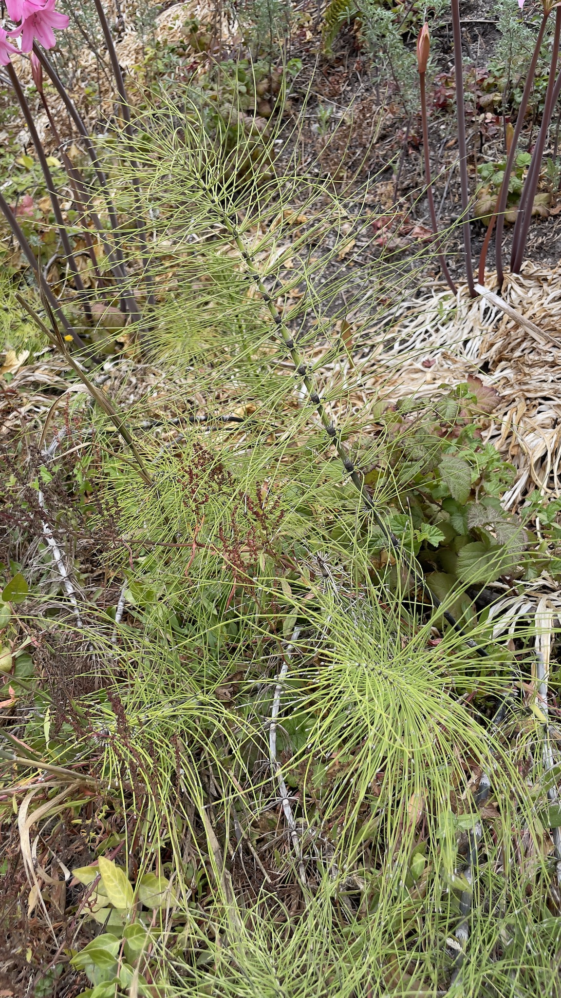
One plant that I hadn’t expected to see in this location is Equisetum, the horsetail. There is a lot of Equisetum along the Marsh Trail, and I associated this plant with wetlands. So why was it growing on this particular slope, which is measurably drier than the Marsh Trail? It was growing really well, too!
2021-08-14
© Allison J. Gong
And see how lush it is growing along the Marsh Trail?

2021-08-14
© Allison J. Gong
We hiked the Marsh Trail—how could there be so many mosquitos when we’re in such a bad drought??—and crossed Waddell Creek to where the Skyline to the Sea trail ends (or begins, if you were to start at the beach and hike uphill). This is where Ranger Fletcher told us more about the fire itself and its ongoing effects.
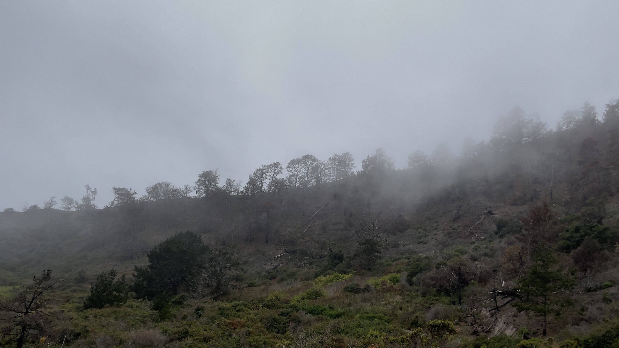
We were hiking at Rancho del Oso on a foggy morning. It was so very different last year, when the marine layer abandoned us early in the summer and left us to dry out just in time for the dry lightning in mid-August. But this is the area where the first lightning strikes hit ground:
2021-08-14
© Allison J. Gong
Once the fire was extinguished this hill was covered with black, burnt vegetation. Anything green is vegetation that has grown since then.
CalFire declared the CZU Lightning Complex fire contained on 22 September 2020 and controlled on 23 December. What nobody knew at the time was that the fire remained burning underground. Considering their great height, redwood trees don’t have deep roots. But they have lateral networks of roots that entwine with those of neighboring trees (which are likely to be clonemates) and form a more or less solid mesh that holds all of the trees up. The fire travelled along this root network and continues to burn. One of our group asked “What is there to burn, if the roots have already burnt?” and Ranger Fletcher explained that now there are tons of charcoal buried in the ground, and we all know how well charcoal burns, right? Not being able to detect where roots are burning underground means it’s difficult to evaluate trails and know when they are safe. Just last week a ranger was working up at Big Basin and stepped into what turned out to be a cavern containing burning embers. CalFire estimates that the fire will continue to burn underground for another four years. Trees that were weakened or killed by the fire will also be falling. It will be several years before the Skyline to the Sea trail opens again. But in the lifespan of a redwood forest, five or even ten years would be a blink of the eye. And I’d just as soon not step into a burning hole while hiking, thank you very much.
On this side of Waddell Creek you can see the meadow that acts as a buffer zone between the mountains and the ocean. When wildfires burn through hilly areas, we worry about winter rains causing mudslides. This past winter we got hardly any rain at all, so at least the mudslides didn’t materialize. But even when there aren’t mudslides, a lot of nutrients wash downhill towards the ocean. The meadow is a biological sponge that soaks up these nutrients and keeps them from creating problems in the marine habitat. This is one of the reasons that wetlands are such important players in the health of coastal ecosystems. I took this photo from the Highway 1 bridge that crosses Waddell Creek. Just on the other side of the highway the creek spills onto Waddell Beach.

2021-08-14
© Allison J. Gong
From a fire behavior perspective the CZU Lightning Complex fire was unusual. Fires usually burn up hills, but this one burned downhill towards the ocean. Waddell Beach is almost always foggy, and the marine layer can be felt away from the beach, as it was on our most recent visit to Rancho del Oso. This marine influence should have acted to keep the fire from racing downhill as fast as it did. Alas, the marine layer was not doing its job last summer. If it had been, we wouldn’t have seen so many lightning strikes in the first place. The paucity of rain from the previous winter didn’t help things, either. Climate change is coming back to bite us in the ass. Around the world we are seeing extreme weather events, from severe drought to equally devastating floods to heat records tumbling by the wayside. We are living in the era of anthropogenic climate change, and we will not be alive when an equilibrium returns to Earth’s climate. In the timeframe of a human lifespan, however, it is nice to see and document how this small part of the landscape is recovering from last year’s fires. Now that Rancho del Oso is open again I’ll try to get up there every so often to record changes in my nature journal.
Absolutely fascinating post! I remember when you were talking about being packed and ready to evacuate and being relieved when you didn’t have to go!
Your photos are so great! That’s crazy about the horsetail being up away from the “wet”! I wonder what the story there is!